
Hannah Kaemmer
Expertise and Empire: Fortification Building and the English Ordnance Office, 1660–1714
In 1705, on the eve of his return to London from North America, the German English engineer Wolfgang William Romer (1640–1713) prepared a perspectival watercolor, entitled Prospect Draft of Fort William & Mary on the Piscataqua River in the Province of New Hampshire on the Continent of America, to serve as a record of the fort’s completion. Viewed from a rocky outcrop to the south, the fort’s freshly mortared stone ramparts and a newly constructed wooden palisade are set between a ship in the harbor at right and the silhouette of “the Towne of New Castle” at left. Smoke emanates from the chimneys of the “old Guardhouse” as well as the “new mad Lodgings,” though both buildings are obscured by the low viewpoint, which conceals rather than exposes the engineer’s accomplishments. Instead, the panoramic view emphasizes the fort’s surrounding landscape, with labels A through S identifying civil and natural as well as military sites, including: M) “Part of the Province of Main [sic]”; R) “Justice Atkinson’s house”; and even S) “The Province Gally Capt. Cyprian Sauthack Commander.” Looming above the scene is a billowing, oversize Union Jack, an irrefutable claim of English supremacy in a colonial outpost.
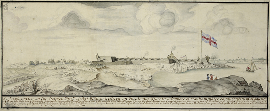
Wolfgang William Romer, Prospect Draft of Fort William & Mary on the Piscataqua River in the Province of New Hampshire on the Continent of America, 1705, ink wash on paper, The British Library. Courtesy of the British Library, K.Top.120.29
Romer’s image encapsulates the central themes of the research I have undertaken during my fellowship. My broader dissertation explores the crucial role played by military engineers, as well as the state institutions that deployed and oversaw them, in the making of the British Empire. In the second half of the 17th century, England extended its colonial territories and, simultaneously, sought to centralize the empire’s administration from London. In this contradictory moment of expansion and consolidation, my dissertation argues, military engineering emerged as a means of imposing English state power on distant and diverse colonial territories.
Central to this story is a single government institution, the English Ordnance Office. Traditionally charged with supplying arms to the army and navy, in the later 17th century the Ordnance Office became the institutional center for fortification-building both within England and throughout its empire. From 1660 to 1714, it established and oversaw a cadre of engineers who managed building projects from Tangier to Ireland, Newfoundland to Jamaica. This profound transformation was never seamless; rather, it depended on complex negotiations among engineers, officials, and laborers with distinct fields of expertise, working in unfamiliar geographies far from the metropole. How, my project asks, did the Ordnance Office gather information about these distant environments and sites; establish authority in colonial settings; and manage the movement of materials, people, and ideas as it fortified diverse territories? To answer that question, my project toggles between metropole and colony to trace the growing, though always tenuous, centralization of imperial fortification in this period. Examining projects in North Africa, Ireland, North America, and the Caribbean, it demonstrates how the English state used bureaucratic systems, visual representations, a global trade network, and the expertise of engineer-agents to stitch together an engineering apparatus capable of defending—and constructing—an empire.

Wolfgang William Romer, A Mean Draft of Her Maj.ties Fort William and Mary on Piscataqua River America, 1705, ink wash on paper, The British Library. Courtesy of the British Library, K.Top.120.28.a
During this fellowship year, I have focused on the visual production of Ordnance engineers, which ranges from the cartographic to the topographic, from the abstract to the experiential. Prior to 1660, information about English fortifications was communicated primarily if not exclusively through the written word. Yet in the aftermath of the Restoration, there was an explosion of fortification image-making, a transformation inseparable from the administrative consolidation of fortifications within the Ordnance Office. The need to comprehend and oversee projects in overseas as well as domestic settings prompted the Ordnance Office to experiment with new visual methods. In addition to plan and section drawings, Ordnance engineers began to capture fortified landscapes in highly evocative watercolor views like Romer’s Prospect. First appearing in the Channel Islands, Tangier, and Ireland from 1680 to 1685, by the turn of the 18th century Ordnance engineers were deploying this strategy at sites across the empire. These drawings offered an unprecedented glimpse of colonial fortifications, and, as Romer’s Prospect suggests, they also provided London officials with a granular, textured view of unfamiliar landscapes and territories, creating narratives of place that made it possible to comprehend, experience, and even possess a distant fortified environment.
Territorial control through the medium of the topographic image was, ultimately, only abstract. Nevertheless, the proliferation of perspectival watercolors produced by Ordnance engineers in the decades around 1700 signals a turning point in the visual practices of the Ordnance Office and, simultaneously, suggests the role of military engineers in the production of picturesque colonial landscapes.
Harvard University
Robert H. and Clarice Smith Fellow, 2023–2024
In August 2024, Hannah Kaemmer will begin a Barra Postdoctoral Fellowship at the McNeil Center for Early American Studies at the University of Pennsylvania.