Skip to Main Content

Members' Research Report Archive

Mapping the Construction Industry in Interwar Germany (1914‒1945): Digital Methods and Architectural Historical Sources

Paul B. Jaskot, DePaul University
Andrew W. Mellon Professor, 2014–2016

jaskot-2015-2016

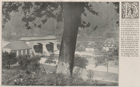
H. Wielandt, architect, Murg River Valley Dam, Baden, as illustrated in Deutsche Bauzeitung 54, no. 3 (January 10, 1920), n.p.

What architectural and political role did the construction industry play in Germany from World War I through World War II? The answer to this question lies in an architectural history from below, an account of history that by necessity involves, for example, a discussion of materials more than of design. The question also raises significant problems involving the use of architectural historical sources as well as the management of large structural questions in the discipline.  Visualizing evidence in a digital mapping environment is one approach to these challenges. The use of digital methods can expand the art-historical research process but also indicate a means of developing art-historical research questions in fundamental ways, for example, in reorienting the history of German architecture from World War I through World War II from a focus on single buildings to patterns in the development of the built environment as a whole.

My work at CASVA (with Ivo van der Graaff, research associate) has centered on the historical problem of the German construction industry. To address this topic, we have developed a database of projects from the important architectural journal Deutsche Bauzeitung as well as working draft visualizations of that database using the computer mapping environment of geographic information systems (GIS). We have also compiled a comparative database from the archive of Dyckerhoff & Widmann, one of the largest construction firms in Germany during this period. The visualizations of these databases in GIS point us to patterns of individual buildings and building types that were previously invisible in the architectural record and now arise in need of further exploration. Thus, for example, Carl James Bühring’s housing estate in Leipzig-Mockau (1919–1923) suddenly appears as much more relevant to architectural debates and interests than previously assumed. The Mockau estate and H. Wielandt’s Murg River Valley Dam in Forbach (Baden [1918]) are kinds of buildings that become the “dark matter,” sustaining the few star monuments like Erich Mendelsohn’s Einstein Tower (1922) that are so much the focus of architectural history. The visualization of an architectural database gives form to human actions and structural patterns that redirect the art-historical question from the object as an isolated monument to what construction of multiple buildings can tell us about society as a whole. In the process, it allows us to gain in new ways a more complex and thus more historical understanding of German architecture from 1914 to 1945.

A study of the production of the built environment more broadly means attending to the construction process as worthy of its own history and concentrated analysis, a topic that takes up the tradition of social art history emanating from Arnold Hauser (1892–1978) and others. Digital methods allow us to ask such broad social questions. Naturally, there is no one single source for the construction industry, and the number of buildings, large and small, vernacular to high design, is almost impossible to capture. Digital methods, however, are meant to tackle large datasets, and the ability of GIS to map spatial information can help us to address this large-scale problem.

Combining the relational capacity of both historical evidence and the methods of digital mapping is a powerful means of visualizing the social dynamics and significance of architectural production. Visualization in this sense is morphological. It gives form to otherwise hidden connections between individual objects and social developments. Digital mapping exposes new problems and areas of research, particularly around the mediating role that culture itself takes in developing and reproducing dominant social structures. In addition, it points to how the capacity for certain cultural, political, or economic events to dominate a social field builds gradually in micro-durations. In these ways, mapping information from historical journals and other archival sources can point to potential activators or inhibitors of social and cultural change in the history of architecture. Such a visualization is a morphological intermediary step that gives shape to the social by reforming the evidence and its biases. It can yield patterns and results that we can analyze as the characteristic relational factors of a social system—in this case, the complex built environment of Germany from before the Weimar Republic through the National Socialist period. In other words, the maps and their attendant database extracted from the journals do not transparently represent the system but rather visualize the emergent properties of cultural systems; the spatial pattern—that which gives shape—resides in between the chaos of historical experience and the artificial uniformity of historical analysis.
Cultural Fantasies, Ideological Goals, and Political Economic Realities: The Built Environment at Auschwitz
Paul B. Jaskot, Ailsa Mellon Bruce Visiting Senior Fellow, September 1–October 31, 2012

Building, Trotz Alledem! Mapping Construction in Germany, 1914–1924
Paul B. Jaskot, Andrew W. Mellon Professor, 2014–2016